By Tom Frantz
On a Saturday morning in early November, several people, including myself, boarded a Cessna T210 for a flight around the southern end of the San Joaquin Valley. The Valley was in the middle of an unprecedented siege of floating dust and soot in the air so the views were anything but sparkling clear. You can see the haze clearly in a video of the flight at https://youtu.be/-MHt-FK2JXQ.
We flew around 2,000 feet up, which seemed to be near the top of the inversion layer. Above the plane, the sky was blue and the Sierra Mountain peaks were sharp. Below, a hazy gray-brown fog saturated the air. This soup of particulates was being inhaled by millions of Valley residents.
Farmworkers with handkerchiefs over their noses were in brown fields below planting new almond trees and elsewhere pruning dusty branches out of mature ones. Some workers were beginning the late fall harvest of seedless mandarins called “Halos.” League championship cross-country competitions were being held. Child athletes and their parents wondered why the best times were slower than expected.
Heading east from the Bakersfield Airport we crossed the Valley’s main artery, Highway 99, which was choked with diesel trucks and cranky drivers. An oil train from Alberta was rumbling south on one side of the highway. We observed the Calloway and North Kern canals carrying fresh Kern River water north to partially satisfy infinitely thirsty fields. The Friant-Kern Canal ran parallel to these others but carried water from the San Joaquin River to the south.
There were huge percolation ponds in both directions of the plane storing water for future years of drought on behalf of a few large corporate farms. Some of these ponds were also receiving salty and toxic oil field wastewater from the nearby Kern River and Poso Creek oil fields.
Soon, we passed over a large dairy near Interstate 5 with more than 7,000 cows. There were around 500 small crates in one corner of this milk factory with calves inside who were being bottle-fed their mothers’ milk plus antibiotics and vitamins to quickly produce the veal cutlets eaten by people in fine restaurants who have no clue where the tender white meat originated. This dairy had an interconnected complex of wastewater lagoons 200 feet wide and a quarter mile long where the liquefied manure was having the shit beat out of it with floating paddle machines in order to send as much ammonia into the air as possible.
Most dairies around the Valley do not have enough land to absorb the nitrogen their cows produce so they dump it into our air where it forms more than half of the fine particulates we were flying through in the form of ammonium nitrate.
This dairy is probably in line to receive a couple million dollars from the state to install a digester. It will then be allowed to burn captured methane to produce electricity. This energy will not be used onsite but rather be sold to power providers at an extremely high price because it will be contracted as negative carbon energy and designated for charging electric vehicles under the state’s low carbon fuel standard. This dairy will likely profit more on its manure than on its milk.
Meanwhile, local residents will breathe the extra pollution from this new source of combustion.
Flying over Tupman, we observe the Tule Elk Preserve. Here the land baron, Henry Miller, as he drained thousands of acres of surrounding swamp in the mid-1800s, discovered a few remaining elk from the original half million that had once roamed the Valley floor. He set aside a small parcel for them where a couple dozen still live today in a state park.
We noticed the infamous Elk Hills Oil Field to our south. This was once owned by the government as a national oil reserve. It later became part of the Teapot Dome Scandal when President Warren Harding leased the oil rights cheaply to his friends. Eventually, starting with orders from Ronald Reagan, it was sold off, with secret bids, to Occidental Petroleum.
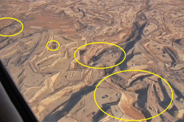
A point of special interest for the passengers on this flight was the nearby Cymric Oil Field (see photo). This is where millions of gallons of crude oil have been leaking up to the surface and into dry stream beds (let’s hope it doesn’t rain soon). The oil and associated toxic water has been surfacing because of massive steam injection nearby in a common form of enhanced oil production. Since last April, California has made forcing oil out of the ground this way illegal.
As we swept around the southwestern end of the Valley, we passed over the towns of Taft and Maricopa and the surrounding oil fields that are among the oldest in California. Old dirt berms were visible where oil had pooled from early gushers more than a century ago. Massive wastewater percolation ponds were visible reflecting odd iridescent colors because of the oil scum floating on their surface. Everywhere were giant power plants and steam generators that add greatly to local air pollution as they burn natural gas.
Finally, we crossed over the southern end of the Valley and squinted through the pollution toward the extensive Wind Wolves Preserve owned by the Wildlands Conservancy. This preserve consists of 93,000 acres of rolling hills, canyons and higher elevation oak and pine forest land once occupied by Native Americans who left extensive and beautiful artwork on the rock walls of certain caves.
Three hundred tule elk live on the preserve today along with many endangered species such as the San Joaquin kit fox. California condors frequently soar over this area just as we were doing.
Native plants such as salt bush are slowly being reintroduced into the preserve and intensive rotational grazing practices are putting carbon into the soil. The brilliance of local preserve manager Landon Pepple, a young man from Minnesota, who organized the flight, was impressive.
It was worthwhile seeing a wide section of the Valley close-up from above. The juxtaposition of natural beauty mixed with the results of human interference, both good and bad, was difficult to comprehend but certainly food for thought.
*****Longtime clean air advocate Tom Frantz is a retired math teacher and Kern County almond farmer. A founding member of the Central Valley Air Quality Coalition (CVAQ), he serves on its steering committee and as president of the Association of Irritated Residents. The CVAQ is a partnership of more than 70 community, medical, public health and environmental justice organizations representing thousands of residents in the San Joaquin Valley unified in their commitment to improving the health of Californians. For more information, visit www.calcleanair.org.